Spatial Analysis
- Home
- Services
- Spatial Analysis
Spatial Analysis Services
Turning Complex Geospatial Data into Strategic Insight
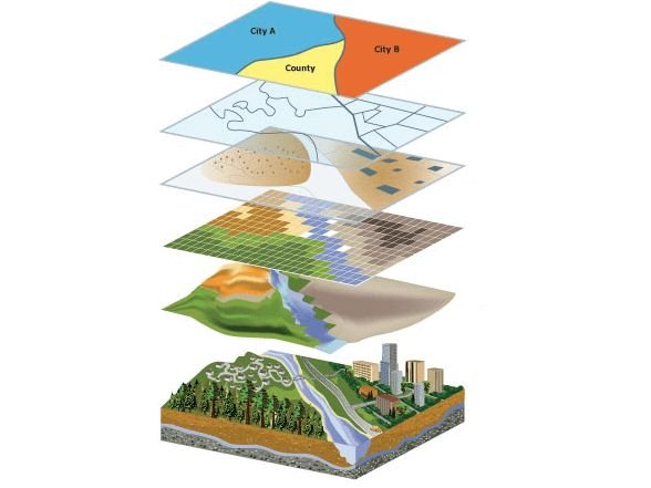
At RJR Services, we specialize in Spatial Analysis — transforming raw satellite, environmental, and field data into meaningful insights that drive smarter, more sustainable decisions.
From climate impact assessments to carbon farming potential and infrastructure planning, our spatial analytics solutions empower organizations to see patterns, understand relationships, and predict outcomes that traditional analysis can’t reveal.
🌍 Why Spatial Analysis Matters?
In an interconnected world, location intelligence is everything.
Spatial data helps identify environmental risks, optimize land use, assess carbon yield, and guide climate adaptation strategies.
By combining GIS, remote sensing, and GeoAI, RJR Services delivers powerful analytical outputs that turn geographic data into business and environmental advantage.
Our Approach:
Our approach integrates science, technology, and strategy to ensure that every spatial analysis is actionable, transparent, and aligned with real-world goals.
- Data Acquisition
- Processing & Analysis
- Visualization & Interpretation
- Validation & Delivery
Our Core Spatial Analysis Services
Environmental & Climate Analysis
Understand and visualize the impact of environmental variables on your operations.
Land degradation and erosion modeling
Climate zone and rainfall distribution mapping
Flood, drought, and heat risk assessments
Biodiversity and ecosystem service mapping
Carbon Potential & Sequestration Analysis
Identify and quantify the carbon value of your land.
Soil and biomass carbon mapping
Carbon sequestration modeling and forecasting
Carbon offset zone prioritization
Integration with carbon credit methodologies
Agricultural & Vegetation Analysis
Empowering precision agriculture through geospatial intelligence.
- Crop health and yield prediction (NDVI, EVI indices)
- Soil moisture and nutrient variability mapping
- Vegetation density, stress, and species classification
- Land suitability modeling for regenerative agriculture
Spatial Risk & Resilience Analysis
Predict, prevent, and plan for climate and operational risks.
- Hazard and exposure mapping (fire, flood, drought)
- Infrastructure vulnerability assessment
- Climate resilience modeling for assets and communities
- Scenario-based planning and impact forecasting
Urban & Infrastructure Spatial Analysis
Integrating sustainability into infrastructure and regional planning.
Urban heat island mapping
Green space and land-use optimization
Infrastructure expansion impact assessment
Spatial planning for low-carbon urban design
Custom GeoAI and Predictive Modeling
Harnessing Artificial Intelligence to analyze spatial patterns and predict outcomes.
- Machine learning for land classification and change detection
- Predictive modeling of land use and vegetation cover
- Anomaly and trend detection for continuous monitoring
- AI-based decision-support dashboards
From Data to Decisions
Spatial data is powerful — but only if it’s analyzed with purpose.
At RJR Services, we turn pixels into patterns, and patterns into plans — guiding organizations toward smarter, data-backed sustainability and climate resilience.
Why Choose RJR Services:
Way Towards Net Zero:
Expertise across GIS, Remote Sensing, and Environmental Science
Integration of spatial, temporal, and climate datasets
Advanced analytics powered by GeoAI and machine learning
Custom dashboards and visual reporting
Accurate, validated, and actionable insights
To help drive the transition to net zero, the Australian Government has set a target to reduce emissions to 62-70% below 2005 levels by 2035. Australia’s abundant renewable energy resources provide the foundation to decarbonise our electricity system, reduce our reliance on fossil fuels in industry, transport and buildings through electrification, and produce new green commodities.